3 common questions from new users.
By Sam Rohr
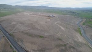
Over the past decade, landfill GPS systems have gone from being a relatively unknown piece of hardware to being one more common tool at the disposal of landfill managers. These systems help landfills improve compaction, build to grade and monitor progress. Landfill GPS system vendors all provide training, but managers may still have questions about how best to use their new equipment. The following are a few common questions that landfill managers who own, or are considering purchasing a GPS system, often have.
Images courtesy of Geologic Computer Systems.
How Do I Locate Buried Objects Like Asbestos and Other Specific Waste Types?
Your landfill GPS system’s mapping and tracking abilities may be one of the most useful features of the system. The system is constantly marking and storing data points as you move around the surface of the landfill. The GPS system allows you to add special tags to these marked data points and store them in the computer for future reference. Let’s say you get a load of hazardous material or something you need to track as you place it in the landfill. With the GPS system you can add a custom tag to the data points you are dropping from the machine and the spot will be marked with the northing, easting, elevation, and date and time stamped to the second.
An example of this from our personal experience is one time we had a customer call us to help locate a specific item in the landfill. Apparently, there had been a murder and the police needed to locate the murder weapon that had been dumped in a dumpster and sent to the landfill. Through some investigation we learned that that dumpster had been picked up at a specific time and the site was able to figure out what time that truck with that load came across the scales. We were then able to look back through the history files on the GPS system and see exactly where and when that load was dumped and were able to provide the police with a range of possible locations for the weapon. They then went to the specified location and were able to find it. This is just one example of a landfill GPS system not only improving your landfills active current performance, but also being able to track and recall the history of your site accurately.
Why Don’t the Waste Density Reports from my Landfill GPS System Match the Yearly Waste Density Figures from My Engineers?
The most common reason is that your landfill map is out of date. It is essential to make sure that the map maintained by your landfill GPS equipment is as complete and recent as possible. Before your landfill GPS vendor installs a system on your machine, they will get in contact with your engineers and get the most recent survey you had done and import it into the GPS system. These surveys are often done on an annual basis and are usually several months old. Because of this, the vendor knows that they will have to update the survey to the current day. Once the GPS system is installed, they will ask you to direct an operator to drive the machine with the GPS system over the surface, mapping and creating a fresh survey as they go.
In order to understand why this is important, you must understand how the GPS system sees the surface of your landfill. As you drive, your machine with the GPS system is mapping the path of travel and storing that real-time mapping data in the system in a map file. This means that any area that the machine drives over, it sees and updates. In any area the machine has not driven over, the GPS system looks for what information it last had on that area. If that information is from a survey done by your engineers several months ago, it may be out of date. If, since that time, the area has settled or been graded, the system will still use the old data from the survey in its map file. This out-of-date data is what causes the errors in your reports. The solution is to update your map, either by surveying it with your new GPS system after installation, or by commissioning a more recent survey.

In fact, when planning to purchase a landfill GPS system, if you can afford it, consider budgeting for a survey to be completed shortly before or shortly after your landfill GPS system is installed. You can use the landfill GPS system itself to do this, but a flyover will give the system a full, up-to-date view of the surface and a great starting point to work from, saving you the time it takes to run the system over all the areas changed since your last survey.
The second most common reason is that some of the equipment making changes to your surface do not have landfill GPS systems on them and are not sharing their work with the GPS system(s) installed on your outfitted machinery. If the GPS system does not drive over and map all changes on the landfill, those missed areas will not show up in your map. Unmapped areas will look like a hole or depression in the surface. Over the years, the equipment cost of GPS systems has gone down as the technology gets more advanced. Most sites today are running multiple systems on different types of machinery, allowing them to share data in real time and keep the surface map constantly updated. This eliminates this issue, due to the fact that all surface work is accounted for by the GPS systems. You can also reduce this phenomenon through smart operator training, so that all operators onsite understand the consequences of working the surface without mapping it. If they understand this and are aware of it, operators and management can work together to map all areas that might have been missed by your outfitted machinery.
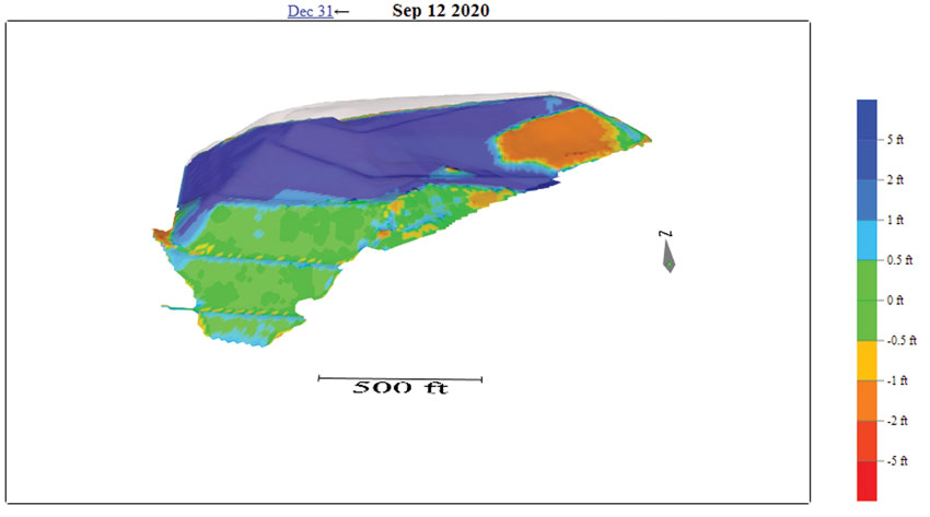
The third most common reason is settlement. Over time, the natural decomposition of the waste below the surface mixed with the immense weight of the waste being added to the top causes the landfill surface to sink. On an area of the landfill where your machines are working and constantly updating the surface, this settlement is not an issue. However, in areas of the landfill where the face has long since been closed, including those where the final grade has been reached and grass sod has been planted, you will have a difficult time keeping track of the settlement in these areas. Once you close a cell and cover it with grass, you obviously do not want to drive your heavy equipment over it to update the settlement in the GPS system. If this becomes a problem for your operation, you can compensate for this by purchasing a low-cost RTK survey system from your landfill GPS vendor, and outfit a vehicle like a UTV or ATV with it. Use this vehicle to periodically drive the areas missed by the other machinery. Alternatively, another increasingly common solution is to conduct drone maps of the surface on a regular basis. Lots of firms provide this service now, and the cost has come down considerably.
How Do I Know the Design from My Engineers, Such as a Top of Waste or Top of Final Cover Design, Lines Up Properly with My Landfill Cells? How Do I Know the Vendor Imported the Surface Properly?
Imagine your landfill design is shaped like a perfect pyramid. However, upon inspection, the edges of the pyramid do not seem to exactly line up with the edge of the landfill cells. You need the ability to determine why this is happening and how to correct it. Before you start working to your new design with your new landfill GPS equipment, it is worth your time and effort to double-check that the design loaded is modeling the surface correctly.
There are good reasons to do this. Sometimes, the mapping provided by previous management, other surveyors or previous engineering firms are lacking. For example, the mapping of cells might be lost, may be incomplete or may have been conducted in an unknown coordinate system. Your current engineers can only do their best with the information provided. There is the possibility that mistakes were made by the engineers in the design. Engineers are human and these things do happen. Finally, the surface imported by your landfill GPS vendor may contain errors. They also may make mistakes, or they may not have been given the surface in a format optimized for a machine model. There is a difference between a model that works on paper, and a model that can be imported as a 3D machine model. All kinds of markup and linework may be added to for the sake of the print that is not required for the machine model and causes problems for the import routine. The best thing to do is to require the engineers to, in addition to the printable design, make a digital machine model of the surface that is “cleaned up” and includes only the surface you intend to model. Alternately, if the model has already been created and cannot be revised by the engineers, reach out to a firm that specializes in turning printable models into machine models.
To validate your design, you will want to find the critical features that define the edges of your cells and compare their location to what you see on the screen of your landfill GPS equipment. You can either do this with your own landfill GPS rover system, or work with your vendor to have this done as part of the initial installation process. If you have posts that mark the edge of waste, make sure the cross section and linework on screen meets up with those posts. If you do not have posts marking the edge of waste, consider carefully digging test pits at the edge of your cells and finding the edge of liner and any important features of the liner such as hinge points. You can then place your rover GPS equipment right on the liner and perform your checks. Finally, make sure you check the design on multiple sides. You could have an error in the calibration of your GPS equipment, or an error in the design, and you may miss it if you only check on one side of the cells.
Understanding the Basics
A GPS landfill system is one of the most significant purchases you can make to ensure that your site is running at maximum efficiency. This will allow all of your personnel to work together and increase your compaction and eliminate costly construction mistakes. With an understanding of these basic concepts, you will ensure that the GPS system is being fully used and returning its investment. | WA
Sam Rohr is the Director of Sales at GeoLogic Computer Systems (Waterford Township, MI), a maker of landfill GPS equipment and software. Sam has 11 years of experience in the landfill GPS market and has supported customers across North America at various MSW and C&D landfills. He can be reached at (248) 635-1408 or e-mail at [email protected].