While technology investments can seem expensive and disruptive to existing operations, GNSS/GPS technology’s long-term benefits will help any operator—and all of our communities—get more out of landfills and do so with less risk.
By Sean Garrett
The demand for landfills is only going to grow along with the population and waste produced. In fact, the global waste management market is projected to see 6 percent compounded annual growth rate each year through 2025. In order to handle this growth and remain good stewards of the land, landfill professionals have a greater responsibility to become more efficient and effective in how sites are managed. The key to these improvements is accurate compaction.
The Technology of the Trade
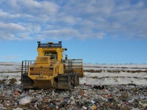
When done right, compaction can reduce common landfill risks, increase land use and improve all areas of landfill management. Many operators rely on experience, intuition and “eyeballing it.” However, these methods are not necessarily effective, regardless of how many years the operator has been in the seat. Among the biggest risks, inaccurate compaction can lead to greater settlement, inefficient use of airspace and shortened life of a cell—all of which result in time and money lost.
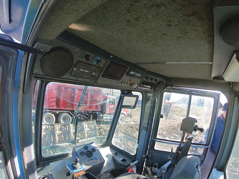
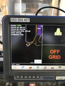
Enter global navigation satellite system/global positioning system (GNSS/GPS) technology. Landfill grade and data management systems are designed to work on existing equipment and deliver real-time data to achieve accurate compaction. How accurate? One example, Carlson’s Landfill GNSS/GPS systems, deliver accuracy to one-tenth of a foot.
The companies that invest in equipment and processes will be poised to grow alongside the industry. By gathering and sharing real-time compaction data, GNSS/GPS technology helps to reduce costs and risk, while maximizing landfill resources. Here are five reasons to invest in one of these systems.
#1: Optimize Airspace
Looking at the big picture and lifetime costs incurred on a landfill, the majority of spend happens daily with waste placement activities. Perhaps the biggest advantage of accurate compaction is the ability to use every cubic yard of airspace to its maximum potential.
As an example of how GNSS/GPS technology systems can improve compaction to optimize airspace, a landfill in Minnesota demoed a system for 90 days and increased compaction by more than 20 percent. Even a more conservative experience, a landfill in Iowa that used the system for a year and improved compaction by 6 percent, is a great example of the success landfills have when using GNSS/GPS technology.
Every site will have its own goal for airspace use. While the EPA standard is approximately 900 pounds per cubic yard, leading companies follow a much higher standard, setting goals closer to 2,000 pounds (1 ton) per cubic yard. GNSS/GPS technology is essential to achieve these higher standards. The real-time data delivery ensures compaction goals are on track and reports prove use goals are being met.
Landfill managers can assign a dollar value to a cubic yard of airspace to help show cost savings of using technology. After doing a site survey and comparing to the engineer’s original file, a landfill in South Dakota saw there was more airspace in a cell that was thought to be filled. Using a GNSS/GPS system, they went back and reclaimed $100,000 in airspace.
Another important advantage of better compaction speaks to both safety and environmental risks. By eliminating pockets where
methane gas can build up, operators can reduce the chance of combustion.
#2: Extend Cell Life
Beyond improving daily cost efficiencies, precise and accurate compaction also affects the bottom line in a bigger-picture, long-term way. Optimized airspace ensures a cell does not fill prior to its projected date. It may even give longer life to an existing cell, deferring the time, costs and environmental impact of creating a new cell.
In Wisconsin, landfill construction costs approximately $275,000 per acre. By improving compaction and extending the cell’s life by just one year, one landfill was able to generate an additional $8 million for the County.
#3: Manage Stormwater
Landfills have a responsibility to protect human health and the environment. In addition to already-discussed factors like reducing combustion and deferring new cells, stormwater management and eliminating leachate are key to fulfilling this responsibility. Similar to those other factors, these two are more than just environmental and safety concerns, they are an expense to control. At approximately 10 cents per gallon to treat leachate, the costs savings of reducing it can add up quickly.
With the real-time data GNSS/GPS technology offers, operators can instantly adjust, cut or fill as they are working in order to ensure that every cubic yard of airspace is filled to full potential. This eliminates dips and voids that allow stormwater to seep in and pool, thus creating leachate. The operator also can strategically engineer compaction to create slopes that encourage runoff in desired areas.
#4: Eliminate Rework
When landfill sites choose not to use systems that deliver real-time data and reporting, there is no way to be sure that operators hit compaction goals each day. These sites only rely on periodic check-ins, whether using LIDAR, UAVs or other method to survey and assess the site. Depending on how often engineers are brought on for these check-ins, a site could find its compaction goals off by a large margin, with areas that are overfilled and must be reworked.
Whether large excavation and material movement or smaller sliver fills, rework is unpleasant, and takes costly time and resources. Accurate compaction reduces the chance of missing compaction targets and eliminates the potential of expensive, inefficient rework.
#5: Clear Communication and Expectations
It is a reality on many landfill sites: the engineer sets the plan, the landfill manager knows the goal and the operator executes. Yet, the three parties have no way to measure and confirm all aspects are on track every day, which can mean lack of alignment and finger-pointing down the road if targets are not hit.
GNSS/GPS technology fosters good communication between all involved in the landfill. Everyone has access and the ability to review the same data. Teams can discuss strategies to improve or simply have reassurance compaction and fill rates are on target for the long-term life of a cell.
While a great communication resource for existing teams, GNSS/GPS technology is especially valuable when onboarding new operators. In addition to setting clear expectations from the start, real-time data reassures new operators that they are running the machine properly and hitting compaction targets.
Looking Ahead
GNSS/GPS technology has been used in other industries for years, even decades; think machine control guidance on motor graders or auto-steer functions on combines. Yet the landfill industry has been slower to adopt similar technology to help operators accurately cut and fill to near-exact specifications.
While technology investments can seem expensive and disruptive to existing operations, the long-term benefits will help any operator—and all our communities—get more out of landfills and do so with less risk. | WA
Sean Garrett is the National Landfill Manager for RDO Integrated Controls, the technology division of RDO Equipment Co. (Fargo, ND) He is passionate about the landfill industry and enjoys the opportunity to sell and support technology that makes a difference and helps landfill professionals protect human health and the environment more effectively. He can be reached at (612) 816-2509 or s[email protected]. For more information about technology solutions for landfills including Carlson Landfill GNSS/GPS, to browse new and used equipment for sale, or to find the RDO store near you, visit www.rdoequipment.com.